What is OrthomoSAic Mapping?
At TerraScan, we offer orthomosaic mapping—a state-of-the-art service that produces highly accurate, georeferenced aerial maps by seamlessly stitching together drone-captured images. This process is essential for a variety of industries, including construction, land surveying, agriculture, and environmental monitoring, where precision and detail are paramount.
Service packages
-

One Time Orthomosaic
Want an in-depth look at your site, an one-time orthomosaic flight provides a detailed, high-resolution map of your site, offering valuable insights into existing conditions, site layout, and any potential obstacles. It’s perfect for pre-construction planning, project assessments, and capturing a precise snapshot of your site at a specific moment in time.
A One Time Flight comes with:
Orthomosaic Map
4 Corner Photos of the Site
Photo Report
1 Ground Control Point & 1 Check Point
Additional Ad-Ons
Plan Document Overlays
Stockpile Analysis & Report
Roof Report
Pavement Report
3D Model
Point Cloud
Elevation Map/Digital Surface Model
Additional Ground Control Points & Check Points
-

Orthomosaic Subscription
Want to see your site come alive? Recurring orthomosaic flights allow you to monitor your site’s progress over time, providing a visual development timeline and changes. This ongoing data helps track construction progress, manage site logistics, and identify issues early, ensuring projects stay on schedule and budget while offering stakeholders clear communication tools.
Recurring Orthomosaic can occur weekly, bi-weekly, or monthly. Scheduled flights are largely determined by the weather.
The Orthomosaic Subscription comes with:
Orthomosaic Map
10 Update Photos of the Site
Progress Report
2 Ground Control Points & 1 Check Point
Reduced Rate Additional Ad-Ons:
Plan Document Overlays
Stockpile Analysis & Report
Roof Report
Pavement Report
3D Model
Point Cloud
Elevation Map/Digital Surface Model
Additional Ground Control Points & Check Points
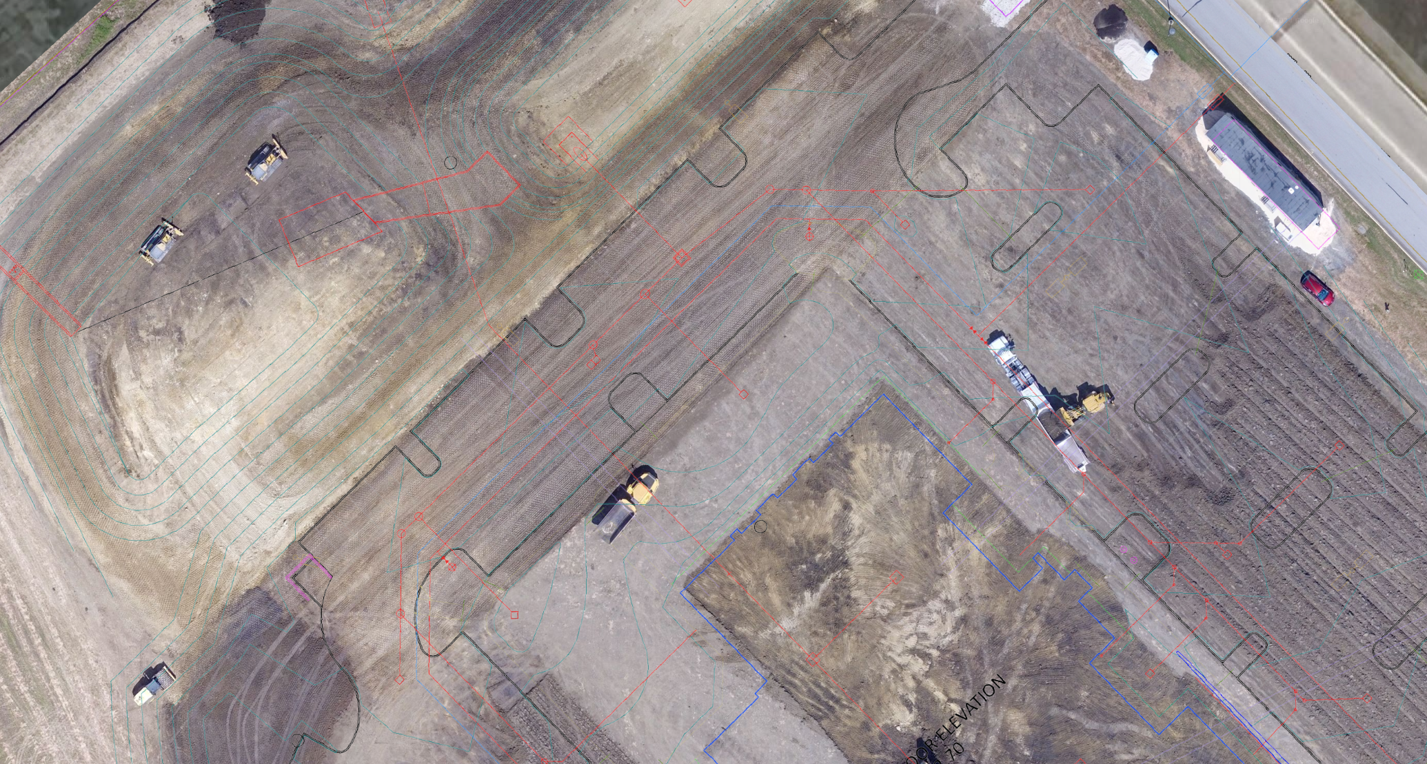
Plan Overlays on Orthomosaics
Our Construction Drawing Overlay service allows you to overlay your construction plans directly onto an orthomosaic map of your site. This service provides a clear visual comparison between the planned design and the actual site conditions, helping you identify any discrepancies early in the construction process.
Benefits of Construction Drawing Overlays
Accurate Alignment: By aligning your construction drawings with a highly accurate orthomosaic, you can ensure that your project is being executed according to plan, reducing the risk of costly mistakes and rework.
Enhanced Visualization: This overlay allows you to visualize how the design fits within the existing landscape, making it easier to plan and adjust as necessary.
Improved Communication: Sharing a visual representation of the project with your team and stakeholders enhances communication and ensures everyone is on the same page, leading to smoother project execution.
Using our Construction Drawing Overlay service, you gain a powerful tool to streamline your project management and ensure precision from planning through to completion.
Stockpile Analysis & Reports
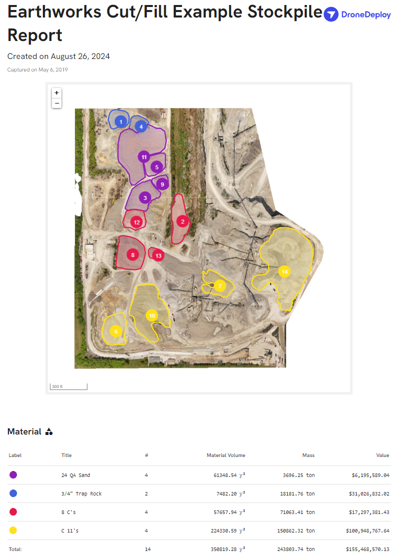
Our Stockpile Analysis & Reports service provides precise measurements and detailed reports on the volume and status of stockpiles on your site, using high-resolution orthomosaics as the foundation. This service is invaluable for industries like construction, mining, and material management, where accurate inventory tracking is essential.
Benefits of Stockpile Analysis & Reports
Accurate Volume Calculations: Using orthomosaics, we can calculate the exact volume of your stockpiles, ensuring accurate inventory management and reducing the risk of over- or underestimating materials.
Efficient Resource Management: By regularly analyzing your stockpiles, you can monitor usage trends, optimize material orders, and prevent delays in your project due to shortages.
Detailed Reporting: Our reports provide clear, actionable data that can be used for planning, budgeting, and compliance purposes, helping you stay on top of your resources and project needs.
With our Stockpile Analysis & Reports service, you gain precise, reliable data to manage your materials more effectively, ensuring that your projects stay on track and within budget.
Roof Report
Our Roof Report service delivers comprehensive assessments of roof conditions using high-resolution orthomosaics, providing detailed insights without the need for physical inspections. This service is particularly beneficial for property managers, roofing contractors, and insurance adjusters who require accurate and efficient roof evaluations.
Benefits of Roof Reports
Detailed Condition Assessments: Our orthomosaic-based reports offer a precise, bird’s-eye view of your roof, enabling the identification of issues such as damage, wear, and structural concerns with exceptional clarity.
Safe and Efficient Inspections: By utilizing drone technology, we eliminate the need for manual roof inspections, reducing safety risks and saving time, especially for large or hard-to-reach roofs.
Comprehensive Documentation: Our reports provide thorough documentation of the roof’s condition, which is invaluable for maintenance planning, insurance claims, and verifying the need for repairs or replacements.
With our Roof Report service, you receive accurate, detailed evaluations that support informed decision-making, helping you maintain the integrity and longevity of your roofing assets.
Pavement Report
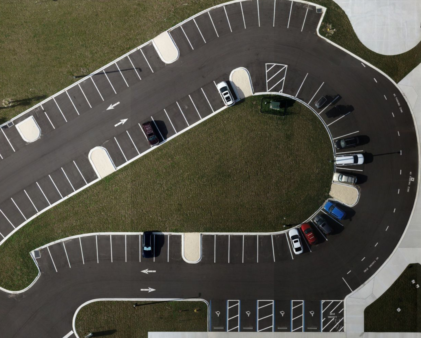
Our Pavement Condition Analysis & Reports service offers a comprehensive evaluation of pavement surfaces, utilizing high-resolution orthomosaics as the foundation for precise and detailed assessments. This service is essential for industries such as road maintenance, construction, and property management, where maintaining safe and functional pavement is crucial.
Benefits of Pavement Condition Analysis & Reports
Accurate Condition Assessment:
By leveraging orthomosaics and advanced imaging techniques, we provide a detailed analysis of pavement conditions, including the precise identification of cracks, potholes, and other surface anomalies. This ensures that you have a clear and accurate understanding of the pavement’s current state.Proactive Maintenance Planning:
Regular analysis allows you to track pavement deterioration over time, prioritize repairs, and schedule maintenance activities effectively. This proactive approach helps prevent minor issues from escalating into costly repairs, thereby extending the lifespan of your pavement.Detailed Reporting:
Our reports deliver clear, actionable insights into pavement conditions, including severity levels. This information is invaluable for budgeting, resource allocation, and ensuring compliance with safety standards.
With our Pavement Condition Analysis & Reports service, you gain accurate, actionable data that empowers you to manage your pavement assets efficiently, ensuring safety, durability, and cost-effectiveness for your projects.
Progress Report
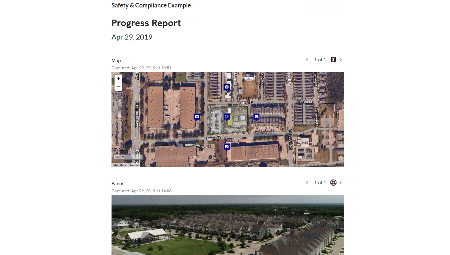
Our Progress Reports service provides a detailed and visual record of your project's advancement, utilizing high-resolution orthomosaics and on-site photography to offer a comprehensive view of progress over time. This service is crucial for industries like construction, real estate development, and infrastructure projects, where keeping stakeholders informed and ensuring timelines are met are essential.
Benefits of Progress Reports
Comprehensive Visual Documentation:
Our service captures and documents every stage of your project through high-resolution update photos and panoramic views. These images are overlaid onto a map plan, providing a clear and accurate visual representation of progress. If requested, this map can be updated with a current orthomosaic, ensuring the most up-to-date view of the site.Enhanced Project Monitoring:
By providing regular updates and visual records, our progress reports allow you to monitor the project’s advancement closely. This enables better decision-making, timely interventions, and ensures that the project stays on schedule and within scope.Detailed Reporting:
Our reports include a thorough analysis of the progress, highlighting key milestones, any deviations from the plan, and providing actionable insights to keep the project on track. This information is crucial for maintaining transparency with stakeholders, planning next steps, and ensuring that all parties are informed of the current status.
With our Progress Reports service, you gain a powerful tool to visually and accurately track your project's development, ensuring that all stakeholders remain informed, timelines are adhered to, and project goals are achieved efficiently.
Photo Report
Our Photo Report service provides a comprehensive visual overview of your site or project with high-resolution images captured during a single drone flight. This service is ideal for clients who require a one-time, detailed photographic documentation of their site, rather than recurring updates.
Benefits of Photo Reports
High-Quality Visual Documentation:
Our service delivers high-resolution aerial images that capture every detail of your site, surpassing the resolution achievable by traditional aircraft photography. The locations of the photos are highly customizable, allowing you to focus on specific areas of interest and ensuring that every critical aspect of your site is documented. These images can be used for a variety of purposes, such as site assessments, project proposals, or marketing materials.Efficient One-Time Service:
Designed for projects where ongoing monitoring is not necessary, our Photo Report service is perfect for clients who need a single, comprehensive set of images. This one-time flight captures everything you need, saving time and resources compared to recurring updates.Customizable Reporting:
The high-resolution images are compiled into a detailed report, providing you with clear and actionable visual data. Whether you need the images for internal review, client presentations, or documentation purposes, our Photo Report ensures that you have everything you need in a well-organized format.
With our Photo Report service, you receive a one-time, thorough visual documentation of your site, offering the perfect solution for projects that require detailed imagery without the need for ongoing updates.
3D Model Creation
3D Model Creation & Analysis Service
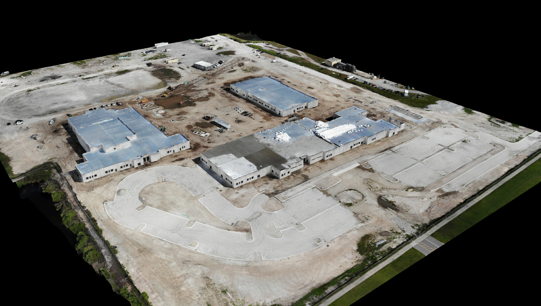
Our 3D Model Creation & Analysis service offers highly accurate, detailed 3D representations of your site or project area, using advanced photogrammetry and drone technology. This service is essential for industries such as construction, urban planning, and environmental management, where detailed spatial information is critical for effective decision-making and project success.
Benefits of 3D Model Creation & Analysis
Precision and Detail: We generate 3D models with exceptional accuracy, capturing every contour and feature of your site. These models provide a realistic view that can be used for planning, design, and analysis, minimizing the risk of errors and ensuring your project is based on precise data.
Enhanced Visualization: Our 3D models offer an immersive experience, allowing you to visualize your project in a way that 2D plans cannot. This enhanced visualization aids in better communication with stakeholders, supports more informed decision-making, and improves project outcomes.
By choosing our 3D Model Creation & Analysis service, you equip yourself with the tools needed to visualize, plan, and execute your projects with greater accuracy and confidence, ultimately leading to better outcomes and more efficient resource use.
Digital Terrain Model & Point Cloud
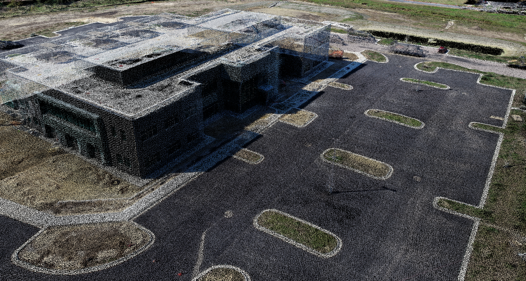
Our Digital Terrain Model (DTM) & Point Cloud service delivers precise, high-resolution models of the terrain and surface features of your site, utilizing advanced drone technology and photogrammetry. This service is crucial for industries such as civil engineering, environmental management, and land surveying, where accurate terrain data is essential for successful project execution and planning.
Benefits of Digital Terrain Model & Point Cloud
High-Resolution Terrain Mapping: We create detailed Digital Terrain Models that capture the elevation and contours of the land with precision. These models provide a solid foundation for project planning, design, and analysis, ensuring that you have accurate data to base your decisions on.
Accurate Point Cloud Generation: Our service includes the generation of dense point clouds, which offer a highly detailed 3D representation of your site. This data is invaluable for identifying and analyzing surface features, structures, and vegetation, providing a comprehensive understanding of the site’s conditions.
Versatile Application: The DTM and point cloud data we provide can be used across various applications, from construction site planning and infrastructure development to environmental impact assessments and land use planning. This versatility makes our service an indispensable tool for professionals across multiple industries.
By choosing our Digital Terrain Model & Point Cloud service, you gain access to precise, detailed data that enhances your ability to plan, analyze, and execute projects efficiently, leading to better outcomes and optimized resource management.
Disclaimer: While our photogrammetry service provides survey-grade accuracy and is highly reliable for a wide range of applications, it is not intended to replace a formal land survey conducted by a licensed surveyor. For legal, regulatory, or official documentation purposes, a signed survey by a certified professional is required.
Elevation Map
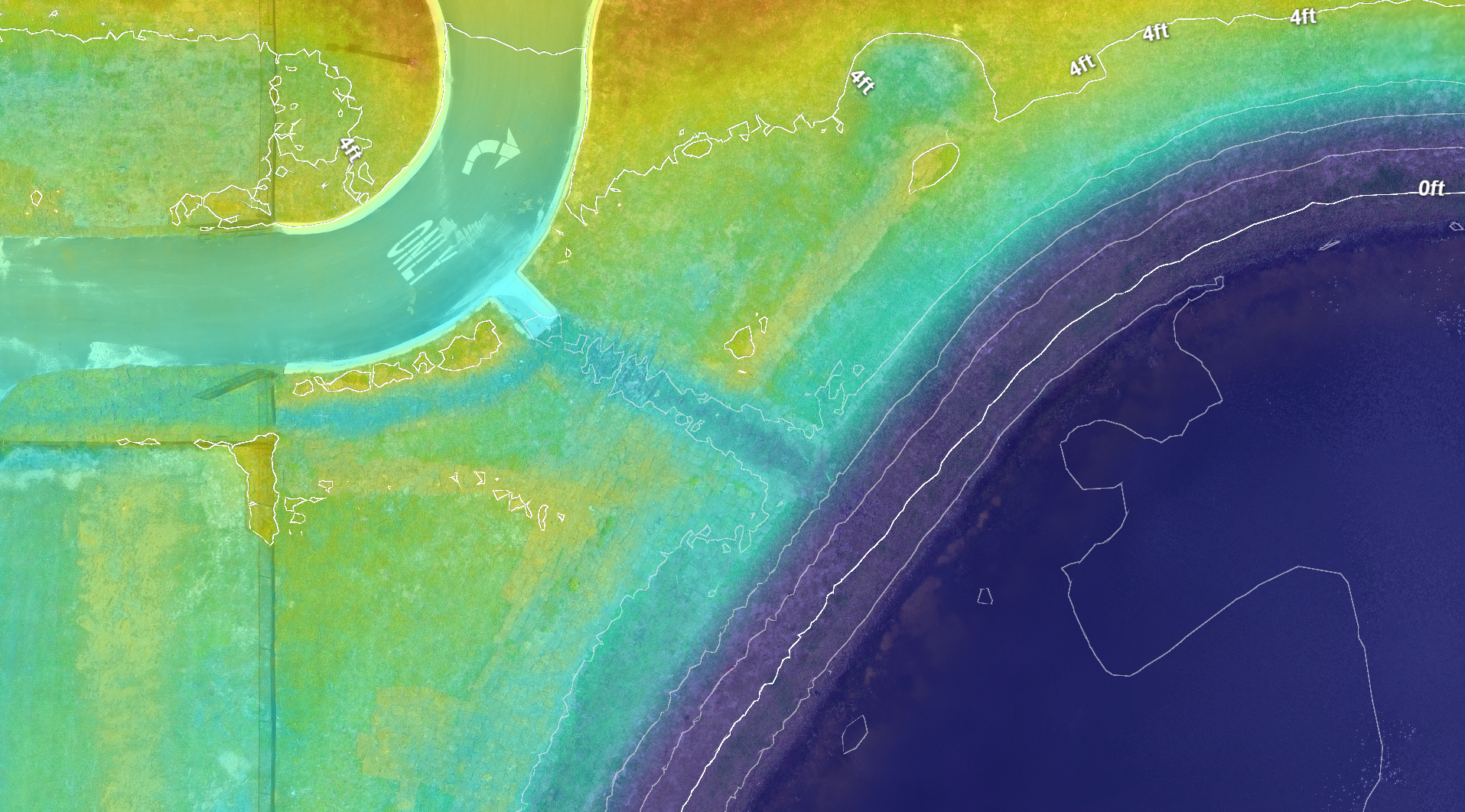
Our Elevation Map service provides precise, detailed representations of the elevation and slope of your site, using advanced drone technology and photogrammetry techniques. This service is essential for industries like construction, land development, and environmental management, where understanding the topography is critical for effective planning and execution.
Benefits of Elevation Map Service
Accurate Elevation Data: We generate highly accurate elevation maps that depict the height variations and contours of your site. This data is crucial for tasks such as site grading, drainage planning, and landscape design, ensuring your projects are based on reliable topographical information.
Enhanced Project Planning: Our elevation maps offer a clear visual representation of the terrain, helping you identify potential challenges and optimize your project plans. Understanding slope and elevation changes allows you to make more informed decisions, including effective drainage planning, reducing risks, and improving project outcomes.
Comprehensive Analysis: In addition to providing elevation data, our service includes detailed analysis that supports project planning, budgeting, and compliance. This analysis helps you understand the terrain's impact on your project, including potential drainage issues, ensuring that you are prepared to address any topographical challenges.
By choosing our Elevation Map service, you gain access to precise, detailed topographical data that enhances your ability to plan and execute projects with greater accuracy and efficiency, leading to better outcomes and optimized resource management.


